Introduction
In a world increasingly impacted by climate change, the need for geohazard assessment has become more critical than ever before. Natural disasters such as earthquakes, landslides, floods, and volcanic eruptions pose significant threats to human settlements and infrastructure. Geohazard assessment involves understanding and analyzing the potential risks associated with these geological phenomena to create safer environments for communities. This article explores the importance of geohazard assessment and the methods used to mitigate the impact of nature’s fury on human lives.
Understanding Geohazards
Geohazards are geological processes or phenomena that can potentially cause damage or harm to the environment and human populations. These hazards can be triggered by various factors, including seismic activity, climate change, weather events, and human activities. Some of the most common geohazards include:
1. Earthquakes
Earthquakes occur due to the movement of tectonic plates beneath the Earth’s surface. These sudden movements release a massive amount of energy, causing ground shaking, surface rupture, and tsunamis. Earthquakes can have devastating consequences for populated areas, leading to loss of life, destruction of infrastructure, and long-term socio-economic impacts.
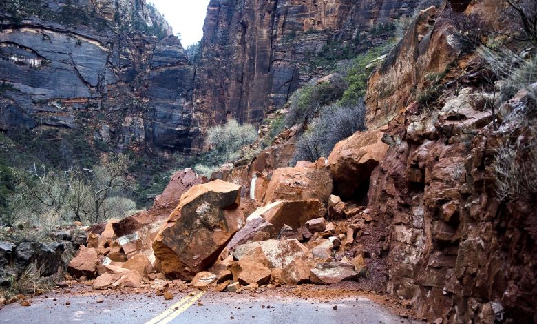
2. Landslides
Landslides are the rapid downhill movement of rock, soil, and debris. They can be triggered by heavy rainfall, volcanic activity, earthquakes, or human interference like construction on unstable slopes. Landslides can destroy properties, disrupt transportation, and even result in fatalities.
3. Floods
Floods occur when there is an overflow of water onto land that is usually dry. They can result from heavy rainfall, storm surges, snowmelt, or dam failures. Floods can cause extensive damage to buildings, crops, and infrastructure, and lead to displacement and loss of life.
4. Volcanic Eruptions
Volcanic eruptions involve the release of magma, ash, and gases from volcanoes. They can have both immediate and long-term impacts, such as destruction of nearby communities, respiratory problems from volcanic ash, and disruption of global climate patterns.
Importance of Geohazard Assessment
Geohazard assessment is crucial for several reasons:
1. Risk Reduction
Geohazard assessment helps in identifying high-risk areas prone to natural disasters. Armed with this information, authorities and communities can implement preventive measures to reduce the impact of such events.
2. Planning and Zoning
The data obtained from geohazard assessments informs urban planning and zoning regulations. This ensures that new constructions and infrastructure projects are located in safe areas, away from potential geohazard risks.
3. Early Warning Systems
Geohazard assessments facilitate the development of early warning systems. These systems provide advance notice to communities, enabling them to take evasive actions and reduce the loss of life and property.
4. Sustainable Development
By understanding geohazard risks, sustainable development practices can be incorporated into infrastructure projects. This prevents haphazard development and minimizes vulnerability to natural disasters.
Methods of Geohazard Assessment
Geohazard assessment involves a combination of field investigations, remote sensing, and advanced technologies. Some of the common methods used for geohazard assessment include:
1. Geological Surveys
Geological surveys involve field mapping and sampling to identify potential geohazards in an area. Geologists study rock formations, soil properties, and the geological history to understand the likelihood of earthquakes, landslides, and other hazards.
2. Seismic Monitoring
Seismic monitoring involves the installation of seismometers to detect and record ground vibrations caused by earthquakes. These instruments provide essential data for understanding earthquake patterns and predicting potential aftershocks.
3. LiDAR (Light Detection and Ranging)
LiDAR uses laser technology to create high-resolution, 3D maps of the Earth’s surface. It is instrumental in identifying areas vulnerable to landslides and floods and helps in assessing terrain stability.
4. Satellite Imagery
Satellite imagery provides a bird’s-eye view of large areas, allowing geologists to monitor changes in landscapes over time. This helps in understanding volcanic activity, glacial movements, and flood-prone regions.
5. Ground Penetrating Radar (GPR)
Ground Penetrating Radar uses electromagnetic waves to detect subsurface features. It is useful in assessing the stability of slopes and identifying potential landslides.
Mitigation Strategies
Once geohazard assessments are conducted and potential risks are identified, it is crucial to implement effective mitigation strategies. Some of the key approaches include:
1. Engineering Solutions
In earthquake-prone regions, engineering solutions like base isolators and flexible building designs can reduce the impact of ground shaking on structures. Similarly, retaining walls and slope stabilization techniques help prevent landslides.
2. Early Warning Systems
Early warning systems for earthquakes, floods, and other hazards play a crucial role in providing timely alerts to communities. These systems allow people to evacuate to safer locations and take necessary precautions.
3. Reforestation and Erosion Control
Planting trees and vegetation in vulnerable areas can help stabilize slopes and reduce the risk of landslides. Additionally, erosion control measures like terracing can prevent soil erosion and sedimentation in river channels.
4. Land Use Planning
Implementing appropriate land use planning and zoning regulations prevents construction in high-risk areas. Building codes should also be enforced to ensure structures can withstand geohazard events.
Conclusion
Geohazard assessment is a vital tool in safeguarding communities against nature’s fury. By understanding and predicting potential risks, communities can plan for the future, implement preventive measures, and create safer environments. The integration of advanced technologies and early warning systems can further enhance disaster preparedness and minimize the impact of geohazards on human lives and infrastructure. As we continue to face the challenges of a changing climate, geohazard assessment remains a critical aspect of ensuring a sustainable and resilient future.